The NSW National Parks and Wildlife Service is planning hazard reduction burns in the Trinkey State Conservation Area and Tinkrameanah National Park from Friday, May 17, weather permitting.
The hazard reduction burn in Trinkey State Conservation Area will commence off Treloar and Yenargee roads as well as Lever Gully roads and is set to treat approximately 626 ha of bushland.
The hazard reduction burn in the Tinkrameanah National Park will burn off near Mitchell Springs Road and is set to treat approximately 390 ha of bushland.
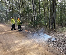
The planned burns will help to improve protection for rural properties and nearby communities in the event of future bushfires. Planned low intensity burns also aim to improve the park’s biodiversity and provide safer access for firefighters.
Smoke will be visible from rural properties in the vicinity of the parks and Tambar Springs.
Roads closed in Trinkey State Conservation Area include:
- Yenargee Road
- Treloar Road
- Lever Gully Road
For their safety, the public should not enter this area while the operation is underway. Roads and trails will be reopened once the area is assessed as safe. Visitors must check National Parks and Wildlife Service alerts for up-to-date information on closures.
Smoke will be visible from rural properties and surrounding areas, including Tambar Springs. Motorists should use caution when driving in the area.


